Property Facts
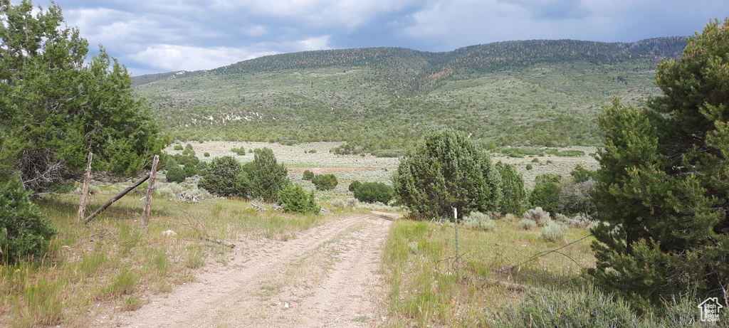
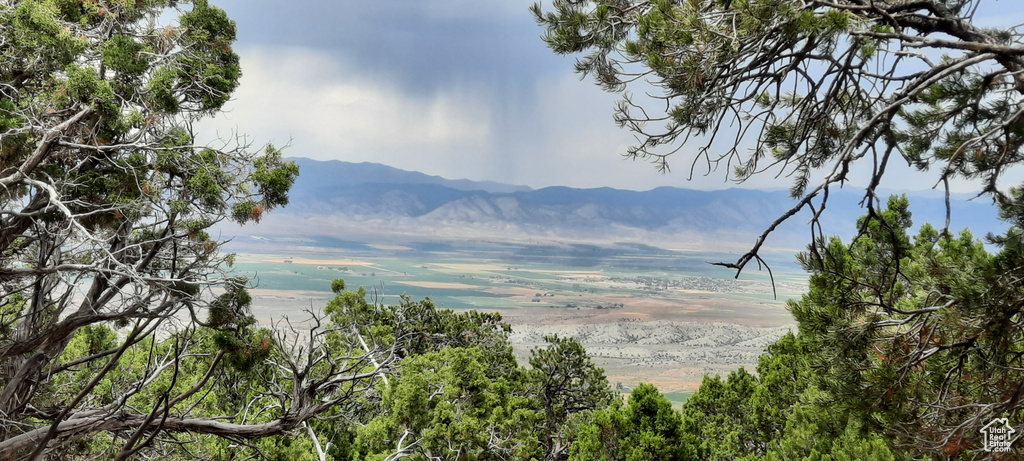
This will be your new happy place.. This get away poperty features beautiful valley views and privacy, and a stream that passes through the property. This property is the only one on the ridge that has level land (about 20 acres) for building and constructing a road to the top. On the top of the ridge is level area with graded area (about 20 acres) with views of both valleys and beyond (east and west) and across the valleys (north and south). Improvements to the property in the valley and the top of the ridge could be connected by a road on the property, from bottom to top, and a well drilled in the valley portion, if the buyer can obtain a well right. The property has a cattle fence on the south, east and west boundaries. Along the east boundary, about 300 feet north of the south boundary is a gate/opening in the cattle fence, with overgrown dirt road to South Hollow Road. On the property this road crosses an intermittent stream gully/wash that diagonally crosses the property on the south and east boundary (follow the cattle fence) to the southeast corner marker. To the west, from inside the valley, on the slope is a large talus scree which marks the approximate north boundary of my property, visible on terrain maps as a large white blob. From valley floor to top of ridge the terrain is steep. About 300-feet from the north boundary on the top of the ridge is a fence and locked gate protecting flat buildable area with views of both valleys from off-road vehicles and squatters - no trespassing signs are mine. Fire roads lead to and cross the ridge from various improved roads and unimproved trails, including on west boundary of the property. Over the property is 16-foot right of way without location description. There are many trails up to the top of the ridge. There are many state designated OHV and horse trails that depart from South Hollow Road to the east towards Mary's Nipple. Privately owned properties on the ridge are surrounded by federal and state lands. Attached is Google map screen shot of 80 acres, USGS protected areas map showing privately owned lands for which the property is in the center, to the north of the 10 acre wide strip. And, two USGS maps of Section 10, topo and aerial. There is a Record of Survey of the 160 acre parcel to the north of my property. Contact the listing agent for the google pin. There is limited cell service, so you will need to set the maps before you leave. You will need a four wheel drive or atv to access the property. This propery is seasonal.
Directions
Exit Mayfield, Utah east on East Canyon Road/12 Mile Road, turn South on South Hollow Road, enter preserve in South Hollow. South Hollow Road splits to right (west after cattle fence) or you can continue south into valley (past reservoir road to east). Where South Hollow Road loop comes back together is another loop. At the south end of the second loop in South Hollow Road, my property is to the right (west) in Order Canyon. Section 10 corner marker establishes the southeast corner, more than 100-feet to the right (west) of the south end of the second loop in South Hollow Road. The southeast corner is located at the corner of a cattle fence on my east and south boundary, in a grove of trees, marked with surveyor tape, to the north of the northernmost 10-acre cabin.
Property Features
Features Include:
- Utilities: Gas: Not Available; Power: Not Available; Sewer: Not Available
- Lot: Excl. Mineral Rights; Excl. Oil/Gas Rights; Fenced: Part; Terrain: Flat; Terrain: Mountain; Terrain: Steep Slope; View: Mountain; View: Valley; Wooded
- Water: Not Available
- Land Use: Pines; Sage; Scrub Oak; Stream
Zoning Information:
- Zoning:
Lot Size In Acres:
- Acres: 80.00
Buyer's Brokerage Compensation
2.5% - The listing broker's offer of compensation is made only to participants of UtahRealEstate.com.
Schools
Designated Schools
Nearby Schools
| GreatSchools Rating | School Name | Grades | Distance |
|---|---|---|---|
| Gunnison Valley School Public Preschool, Elementary |
PK | 4.99 mi | |
| Gunnison Valley Middle School Public Middle School |
6-8 | 4.60 mi | |
| Gunnison Valley High School Public High School |
9-12 | 4.91 mi | |
| Utah Prep School Private Middle School, High School |
8-12 | 9.34 mi | |
| Manti School Public Preschool, Elementary |
PK | 9.91 mi | |
| Utah Preparatory Academy (YIC) Public Middle School, High School |
7-12 | 9.98 mi | |
| Young Women's Empowerment Center (YIC) Public Middle School, High School |
8-12 | 9.99 mi | |
| South Sanpete District Preschool, Elementary, Middle School, High School |
9.99 mi | ||
| South Sanpete Education Support Center Public Elementary, Middle School, High School |
K-12 | 9.99 mi | |
| Manti High School Public High School |
9-12 | 10.35 mi | |
| Anchor Stone Youth Public Middle School, High School |
7-12 | 11.02 mi | |
| North Sevier High School Public High School |
9-12 | 11.23 mi | |
| Salina School Public Elementary |
K-5 | 11.24 mi | |
| North Sevier Middle School Public Middle School |
6-8 | 11.29 mi | |
| Ephraim Middle School Public Middle School |
6-8 | 15.65 mi |
School data provided by GreatSchools.
For information about radon testing for homes in the state of Utah click here.
Contact Agent

Listing Broker

ERA Brokers Consolidated (Richfield Branch)
745 South Main
Richfield, UT 84701
435-896-9609